Vardzia Cave Town
Location & Detailed Description
- Location: Aspindza, Samtskhe-Javakheti Region, Georgia.
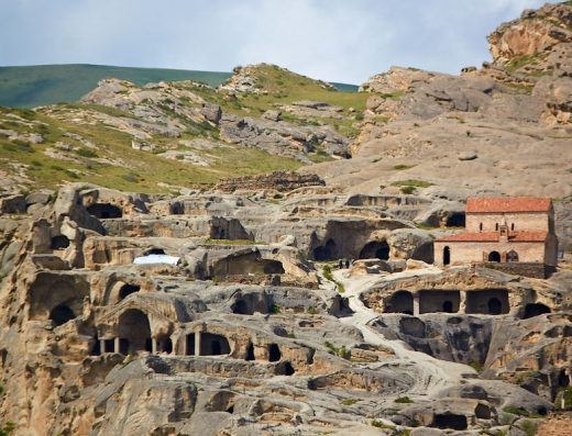
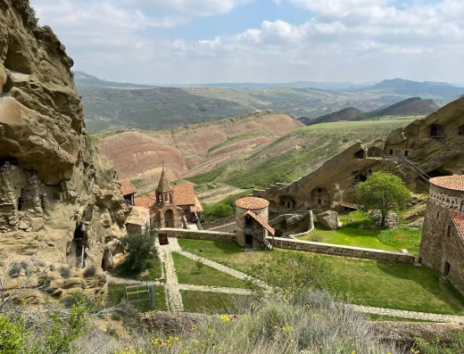
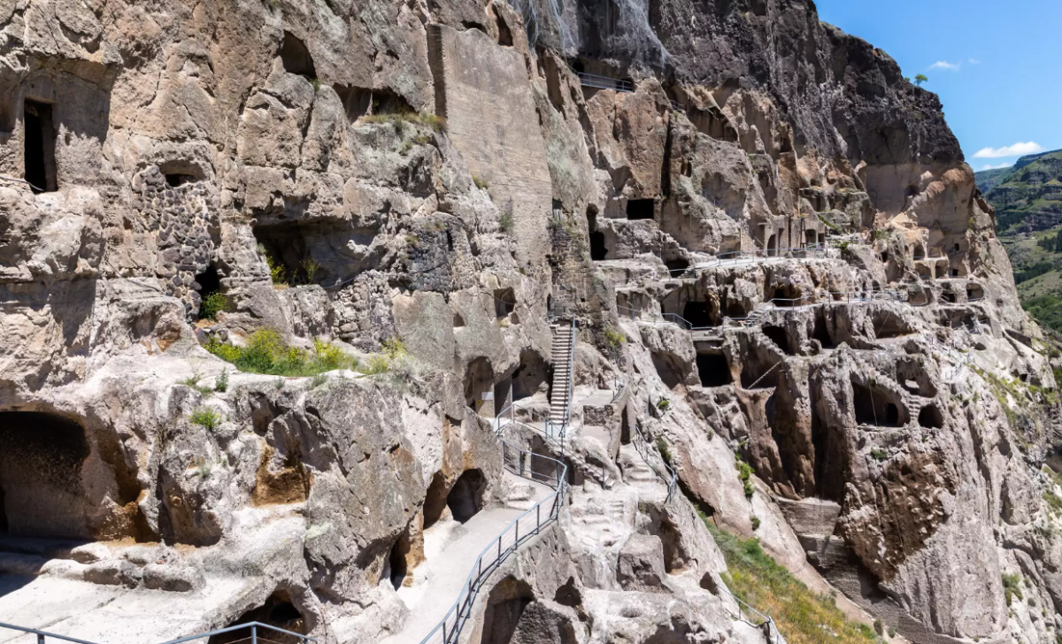
- Introduction and Geographical Infrastructure: Vardzia Cave Town stands as one of the most prominent landmarks of medieval cave architecture, representing a grand, centuries-old urban fortification complex. Geographically situated roughly 300 kilometers away from the capital city of Tbilisi, this historical monument occupies a massive 40,000 square meter cliff face within the ancient Meskheti province. Today, the territory is protected under the jurisdiction of the Samtskhe-Javakheti administrative region. Due to its outstanding historical, archaeological, and aesthetic importance to the nation, Vardzia has officially been granted the protected legal status of an Immovable Cultural Monument of National Significance. It sits on the left bank of the Mtkvari River, meticulously cut into the volcanic tufa stone of the Erusheti Mountain, providing a defensive perimeter over the canyon below.
- Monarchical History and Cultural Golden Age: The intensive physical excavation and primary structural expansion of the site occurred during the prosperous 12th century. The timeline of this complex is historically intertwined with the consecutive golden age reigns of two influential Georgian monarchs, King Giorgi III and his celebrated daughter, Queen Tamar. Originally conceived by King Giorgi III as a strategic military outpost to block invaders from the southern borders, Queen Tamar later completely altered its purpose into a vast, self-sustaining monastic city. Throughout this period of high medieval civilization, Vardzia functioned as the absolute nerve center for the entire country’s political decision-making, cultural development, and religious life, preserving deep physical evidence of highly advanced engineering and organizational systems that flourished centuries ago.
- Complex Architecture and Engineering Layout: Architecturally, Vardzia is an expansive fortress city carved completely into a vertical rock cliff, stretching horizontally across a distance of 900 meters. The subterranean settlement is organized on distinct floor levels stacked across its vertical height, originally reaching up to thirteen tiers. All sectors are interconnected via an intricate network of cut tunnels, vertical escape shafts, and stone staircases. Nearly 900 years ago, this mountain citadel operated with highly advanced public infrastructure, which surprisingly included a functional, stone-carved plumbing network. An internal spring-fed aqueduct system was engineered to deliver fresh drinking water directly to the citizens through clay pipes, showcasing a high degree of hydro-technic expertise unmatched in the region during the medieval period.
- Seismic Damage, Frescoes, and Agricultural Assets: Over the passing centuries, a continuous series of military defensive wars and devastating natural earthquakes inflicted severe structural damage upon this unique rock-hewn layout. The most catastrophic event occurred in the year 1283, when a massive earthquake sheared off the outer rock face of the mountain, exposing the inner hidden caves to the outside world and destroying more than two-thirds of the city. At the absolute center of the remaining cliff complex lies the ancient Dormition of the Virgin Church, which continues to be actively preserved and features walls covered in intricate, historic medieval frescoes. These murals include rare, globally significant historical portraits of King Giorgi III and Queen Tamar. During its agricultural and economic prime, the subterranean city housed 28 extensive wine cellars equipped with 235 traditional earthenware Qvevris, highlighting a massive capacity for regional viticulture. Today, only a small number of these vessels survive, though a total of 242 individual cave chambers remain either partially or completely preserved for modern eco-tourists to explore.
مدينة كهوف فارديزيا (Vardzia Cave Town)
الموقع ووصف تفصيلي
- الموقع: أسبيندزا، إقليم سامتخي-جافاخيتي، جورجيا.
- مقدمة البنية التحتية الجغرافية: تقف مدينة كهوف فارديزيا الأثرية كواحدة من أبرز المعالم المعمارية التي تعود إلى العصور الوسطى، متمثلة في مجمع تحصين حضري ضخم يمتد عبر القرون. يقع هذا النصب التاريخي الشاسع على بعد حوالي 300 كيلومتر من العاصمة تبليسي، ويحتل منحدرًا صخريًا هائلاً تبلغ مساحته 40 ألف متر مربع في مقاطعة ميسخيتي التاريخية القديمة. واليوم، تخضع المنطقة لحماية وإشراف إقليم سامتخي-جافاخيتي الإداري. ونظرًا لأهميتها التاريخية والأثرية والجمالية الفائقة للأمة، مُنحت فارديزيا رسمياً الوضع القانوني المحمي كمعلم ثقافي غير منقول ذو أهمية وطنية قصوى. يقع الموقع على الضفة اليسرى لنهر متكفاري (Mtkvari)، حيث تم نحته بدقة متناهية في صخور الطف البركاني التابعة لجبل إروشيتي، مما وفر محيطاً دفاعياً طبيعياً يطل على الوادي السحيق بالأسفل.
- التاريخ الملكي والعصر الذهبي الثقافي: تم الحفر الفيزيائي المكثف والتوسع الهيكلي الأساسي للموقع خلال القرن الثاني عشر المزدهر. يرتبط الجدول الزمني لهذا المجمع بشكل وثيق بالعهود المتتالية للعصر الذهبي لاثنين من حكام جورجيا المؤثرين، وهما الملك جيورجي الثالث وابنته الشهيرة الملكة تامار. في البداية، تم تصميم الموقع من قبل الملك جيورجي الثالث ليكون بمثابة موقع عسكري استراتيجي لصد الغزاة من الحدود الجنوبية، ولكن الملكة تامار قامت لاحقاً بتغيير الغرض منه تماماً، محولة إياه إلى مدينة رهبانية شاسعة تكتفي ذاتياً. وخلال تلك الحقبة من حضارة العصور الوسطى العليا، كانت فارديزيا بمثابة العصب المركزي والقطب الأساسي لصنع القرار السياسي والتطور الثقافي والحياة الدينية في البلاد بأكملها، محتفظة بأدلة مادية عميقة على وجود أنظمة هندسية وتنظيمية متطورة للغاية ازدهرت منذ قرون مضت.
- العمارة المعقدة والمخطط الهندسي للموقع: من الناحية المعمارية، تعتبر فارديزيا مدينة حصينة شاسعة منحوتة بالكامل في جرف صخري عمودي، وتمتد أفقيًا على مسافة تبلغ 900 متر. تنظم هذه المستوطنة الجوفية على طبقات وطوابق متميزة وموزعة على كامل ارتفاعها العمودي، حيث كانت تصل في الأصل إلى ثلاثة عشر طابقاً. تتصل جميع القطاعات والأحياء ببعضها البعض عبر شبكة معقدة من الأنفاق المحفورة، وأعمدة الهروب العمودية، والسلالم الصخرية. وقبل ما يقرب من 900 عام، كانت هذه القلعة الجبلية تعمل ببنية تحتية عامة متطورة للغاية ومثيرة للإعجاب، والتي اشتملت بشكل مدهش على شبكة سباكة وإمداد مياه وري وظيفية. تم تصميم نظام قنوات مائية داخلي يغذيها نبع طبيعي لتوصيل مياه الشرب العذبة مباشرة إلى المواطنين عبر أنابيب طينية، مما يظهر درجة عالية من الخبرة الهيدروليكية التقنية التي لم يكن لها مثيل في المنطقة خلال فترة العصور الوسطى.
- الأضرار الزلزالية واللوحات الجدارية والأصول الزراعية: على مر القرون الماضية، تسببت سلسلة مستمرة من الحروب الدفاعية العسكرية والزلازل الطبيعية المدمرة في إلحاق أضرار هيكلية بالغة بهذا المخطط الفريد المنحوت في الصخر. وقع الحدث الأكثر كارثية في عام 1283، عندما تسبب زلزال هائل في تمزيق الواجهة الصخرية الخارجية للجبل، مما أدى إلى كشف الكهوف الداخلية المخفية للعالم الخارجي وتدمير أكثر من ثلثي المدينة بالكامل. وفي المركز تمامًا من مجمع الجرف المتبقي، تقع كنيسة رقاد العذراء الأثرية، والتي لا تزال تُحفظ وتُرمم بنشاط، وتتميز بجدران مغطاة بلوحات جدارية وزخارف دينية فريدة من العصور الوسطى. تشمل هذه الجداريات صوراً تاريخية نادرة وذات أهمية عالمية للملك جيورجي الثالث والملكة تامار. وخلال فترة ازدهارها الزراعي والاقتصادي، كانت المدينة الجوفية تضم 28 قبوًا واسعًا للنبيذ مجهزة بـ 235 من أواني الفخار التقليدية الضخمة (Qvevris)، مما يبرز القدرة الهائلة للمنطقة على إنتاج وصناعة النبيذ الإقليمي. واليوم، لم يتبق سوى عدد قليل من هذه الأوعية، على الرغم من أن ما مجموعه 242 غرفة كهفية فردية لا تزال محفوظة جزئيًا أو كليًا ليستكشفها السياح.
Ready to visit? Let our Personal Concierge design a fully tailored trip just for you, or book this exact experience instantly with our trusted partner, GetYourGuide. 🌍
جاهز للزيارة؟ دع خدمة الكونسيرج الشخصي تصمم لك رحلة مخصصة بالكامل، أو احجز هذه التجربة فوراً مع شريكنا الموثوق GetYourGuide. 🌍