Uplistsikhe Cave Town
Location & Detailed Description
- Location: Gori (10 kilometers away), Shida Kartli Region, Georgia.
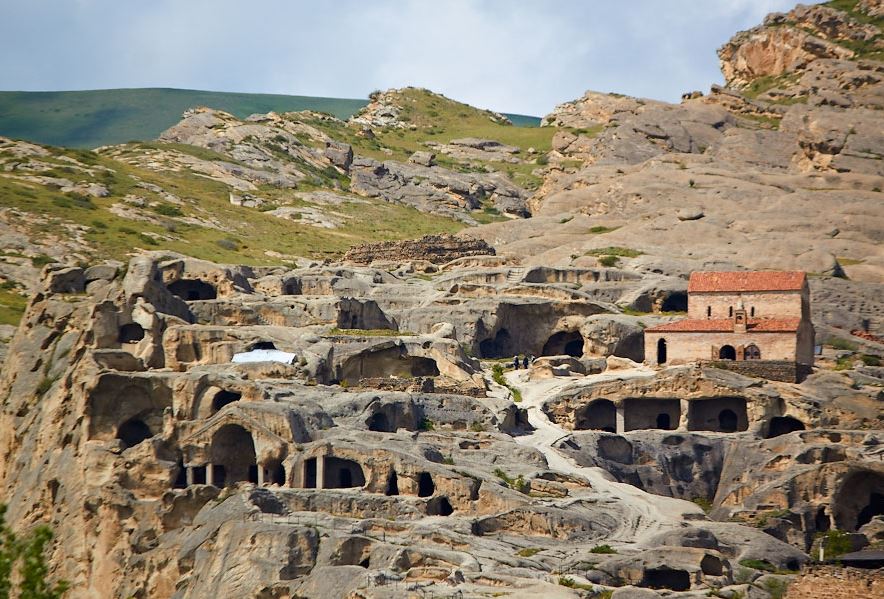
- Introduction and Geo-Historical Context: Uplistsikhe Cave Town stands prominently as an exceptionally ancient, historically rich rock-hewn complex, making it one of the earliest established urban settlements in the entire Caucasus region. Positioned in the Shida Kartli region of Georgia, approximately ten kilometers east of Gori, this sprawling cliffside town represents an architectural masterpiece carved out over successive eras. The foundational roots of this subterranean complex trace back definitively to the late Bronze Age. From the 4th century BCE onward, historical documentation chronicles its strategic evolution into a massive regional spiritual, political, and tribal center. It achieved its ultimate pinnacle of cultural expansion and geopolitical dominance during the 9th and 10th centuries, functioning as an unbreakable regional stronghold. To secure its preservation for future generations, Georgia designated the complex as an Immovable Monument of National Significance in 2006.
- Tribal History and Nomadic Etymology: Literary records and historical chronicles from across the region begin referencing the cliffside complex regularly starting around the 7th century. Initially, the complex developed as a heavily fortified and strategic residential headquarters for a local hegemonic community. Over generations, it successfully transformed into the primary centralized hub for the united tribes that fully controlled the Shida Kartli territories. The absolute ruler and supreme leader of this early tribal union was historically addressed by the title “Upali,” a term translating directly to “Lord” or “Ruler” in the local language. Because this supreme political leader maintained a permanent royal residence inside this heavily fortified cliff fortress, the entire rock settlement gradually became known across the region as Uplistsikhe, an etymological combination that translates directly to “The Fortress of the Lord.”
- The Historical Construction Legend: An enduringly popular local legend documented within the cultural history of Shida Kartli surrounds the extensive, labor-intensive excavation of Uplistsikhe. According to these historical accounts, the massive numbers of slaves tasked with hand-carving the complex out of the solid stone cliffside were intentionally provided with uniquely designed, dual-purpose iron pickaxes. One primary side of these custom labor tools was forged from dense, heavy industrial iron, while the opposing side was meticulously lined with solid gold. The ruling lords decreed a strict motivational pact: any slave who managed to completely wear down and erode the heavy iron side of their pickaxe through continuous rock excavation would be immediately granted total personal freedom, and they were legally permitted to keep the remaining solid gold side as personal wealth to start their new lives.
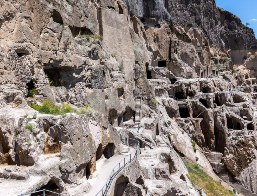
- Architectural Layout and Structural Assets: Today, the protected archaeological museum-reserve displays a sprawling, highly organized ancient city layout that remains entirely bounded by a thick defensive stone wall and accessed through four distinct historic entry gates. Visitors navigating the historic site can walk through a functional, highly sophisticated urban planning grid consisting of carved streets, public squares, open-air markets, and communal residential halls. The vertical rock faces are meticulously excavated to house pre-Christian pagan temples, a fully structured public theater, an advanced ancient pharmacy facility with designated storage compartments, massive stone wine presses, and deep subterranean wine cellars. Additionally, an expertly engineered secret escape tunnel is built directly into the site’s geology, allowing a safe passageway from the internal cave quarters straight down to the banks of the Mtkvari River.
مدينة كهوف أوبليستسيخ (Uplistsikhe Cave Town)
الموقع ووصف تفصيلي
- الموقع: مدينة غوري (على بعد 10 كيلومترات)، إقليم شيدا كارتلي، جورجيا.
- مقدمة والسياق الجغرافي التاريخي: تبرز مدينة كهوف أوبليستسيخ بشكل مرموق كواحدة من أقدم المستوطنات الحضرية المنحوتة في الصخر وأكثرها ثراءً بالتاريخ في منطقة القوقاز بأكملها. يقع هذا المجمع الشاسع في إقليم شيدا كارتلي في جورجيا، على بعد حوالي عشرة كيلومترات شرق مدينة غوري، ويمثل تحفة معمارية فريدة تم حفرها عبر العصور المتعاقبة. تعود الجذور التأسيسية لهذا المجمع الجوفي إلى أواخر العصر البرونزي. ومنذ القرن الرابع قبل الميلاد فصاعداً، يوثق التاريخ تحولها الاستراتيجي إلى مركز روحي وسياسي وقبلي مهيمن في المنطقة. بلغت المدينة ذروة توسعها الثقافي وهيمنتها الجيوسياسية خلال القرنين التاسع والعاشر الميلاديين كمعقل إقليمي حصين. وضماناً للحفاظ عليها، صنفتها جورجيا رسمياً كمعلم أثري غير منقول ذو أهمية وطنية في عام 2006.
- التاريخ القبلي والاشتقاق اللغوي: تبدأ السجلات الأدبية والمخطوطات التاريخية في الإشارة بانتظام إلى هذا المجمع الصخري ابتداءً من القرن السابع الميلادي. في البداية، تطور الموقع كمقر سكني محصن وموقع استراتيجي لمجتمع محلي مهيمن. ومع مرور الأجيال، تحول بنجاح ليصبح المركز الرئيسي الموحد للقبائل التي بسطت سيطرتها الكاملة على أراضي شيدا كارتلي. وكان الحاكم المطلق والزعيم الأعلى لهذا الاتحاد القبلي يخاطب تاريخياً بلقب “أوبالي”، وهو مصطلح يترجم مباشرة إلى “السيد” أو “الحاكم” في اللغة المحلية. ونظراً لأن هذا القائد السياسي الأعلى كان يقيم بشكل دائم داخل هذا الحصن الصخري المنحوت، أصبحت المستوطنة الصخرية بأكملها تُعرف في المنطقة باسم أوبليستسيخ، وهو دمج لغوي يترجم مباشرة إلى “قلعة السيد”.
- أسطورة البناء التاريخية البارزة: تحيط أسطورة محلية دائمية التداول مدونة في التاريخ الثقافي لإقليم شيدا كارتلي بعمليات الحفر الهائلة والمجهدة لمدينة أوبليستسيخ. ووفقاً لهذه الروايات التاريخية، فإن الأعداد الغفيرة من العبيد الذين كُلفوا بنحت المجمع يدوياً في الجرف الصخري الصلب تم تزويدهم عمداً بفؤوس حديدية فريدة التصميم وثنائية الغرض. تم صياغة أحد الجوانب الرئيسية لأدوات العمل هذه من الحديد الصناعي الكثيف والثقيل، بينما تم صقل الجانب المقابل بعناية من الذهب الخالص. وأصدر الحكام مرسوماً صارماً: أي عبد ينجح في استهلاك وإنهاء الجانب الحديدي الثقيل تماماً من فأسه نتيجة الحفر المستمر في الصخور، يمنح حريته الشخصية فوراً، ويُسمح له قانوناً بالاحتفاظ بالجانب الذهبي الخالص كأموال لبناء حياته الجديدة.
- المخطط المعماري والمعالم الهيكلية للموقع: يعرض المتحف الأثري المحمي اليوم مخططاً حضرياً شاسعاً ومنظماً للغاية للمدينة الأثرية، حيث لا تزال محاطة بالكامل بجدار صخري دفاعي سميك ويتم الدخول إليها عبر أربع بوابات تاريخية متميزة. ويمكن للزوار أثناء تنقلهم في الموقع السير عبر شبكة تخطيط حضري متطورة تتكون من شوارع منحوتة، وساحات عامة، وأسواق مفتوحة، وقاعات سكنية مشتركة. تم حفر الواجهات الصخرية العمودية بدقة لتضم معابد وثنية من فترة ما قبل المسيحية، ومسرحاً عاماً متكاملاً، ومنشأة صيدلانية قديمة متطورة مع حجرات تخزين مخصصة، ومعاصر نبيذ حجرية ضخمة، وعنابر جوفية عميقة. بالإضافة إلى ذلك، تم بناء نفق سري هندسي طارئ مباشرة في جيولوجيا الموقع، مما يتيح ممراً آمناً من غرف الكهوف الداخلية إلى ضفاف نهر متكفاري (Mtkvari).