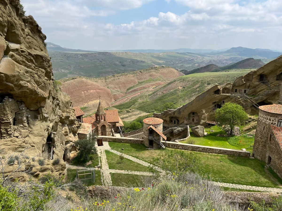
Davit Gareja Monastery Cave Complex
Location & Detailed Description
-
- Location: Sagarejo Municipality, Kakheti Region, Georgia.
- Introduction and Geo-Historical Context: The Davit Gareja Monastery Complex is a prominent rock-hewn Georgian Orthodox monastery ensemble situated on the edge of the Iori Plateau along the half-desert slopes of Mount Gareja. Located approximately 60 to 70 kilometers southeast of Georgia’s capital city, Tbilisi, this massive archeological and spiritual landmark spans a length of 25 kilometers. According to documentation submitted to the UNESCO Tentative List, the site features a rare combination of historic medieval architecture, prehistoric archaeological sites, rich paleontological fields, and distinctive bio-geographical features embedded within an arid and semi-arid ecosystem. In 2008, the complex was officially nominated to the UNESCO World Heritage monuments registry. Due to its deep historical value, it has long been protected as an essential object of national cultural heritage.
- Foundational Monastic Roots: The historical origin of the complex traces back to the first half of the 6th century AD. It was established by Saint David Garejeli, a holy monk who was one of the celebrated Thirteen Assyrian Fathers who arrived in Georgia to solidify Christian preaching. Saint David initially settled within a small, natural rock cave in the remote Gareja desert accompanied by his close disciple Lukiane. Together with other prominent followers such as Dodo, they expanded the original hermit settlement. This initial site became known as the David Lavra, which historically functioned as the central nexus of monastic life in the desert region, laying the immediate foundation for successive surrounding cloisters.
- Structural Expansion and the Golden Age: Over the centuries, the original lavra steadily broadened and gave rise to an entire network of interconnected rock-cut branches. Academic registries and historical lists identify up to 14 distinct monastic ensembles spread across the rugged mountain ridge. Among the most notable complexes are Dodo’s Rka (the Horn of Dodo), Natlismtsemeli (John the Baptist), Udabno, Bertubani, Tsamebuli, Sabereebi, and Chichkhituri. The entire ensemble reached the absolute zenith of its cultural, political, and economic development during the Golden Age of medieval Georgia between the 11th and 13th centuries. The complex effectively operated as a Royal Monastery under the direct patronage and care of the Georgian royal family and noble houses. The 12th-century king Demetre I, the famed author of the historic Georgian hymn “Thou Art a Vineyard,” notably chose Davit Gareja as his place of confinement after abdicating the royal throne.
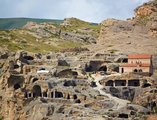
- Architectural Layout and Cultural Treasures: Structurally, the sprawling ensemble encompasses thousands of individual rock-cut cells, churches, chapels, refectories, and living quarters completely hollowed out of the vertical stone cliff face. According to UNESCO data, the compound includes an estimated 5,000 monastic cells alongside numerous specialized caves carved out for everyday practical operations, including ancient bakeries, barns, smithies, and livestock housing, complemented by stone terraces built for agriculture. To ensure sustainability in severe semi-desert conditions, a sophisticated infrastructure grid featuring engineered water supply channels and defensive stone reservoirs was carved into the slopes. Architecturally, the interiors preserve some of the most significant masterpieces of medieval Georgian art. These cave churches house unique mural frescoes dating back as far as the 8th century, showcasing highly important historical portraits of prominent Georgian monarchs, including King David the Builder at Natlismtsemeli and Queen Tamar alongside her son Lasha-Giorgi at the Bertubani monastery.
مجمع كهوف دير دافيت غاريجا
الموقع ووصف تفصيلي
- الموقع: بلدية ساغاريجو، إقليم كاخيتي، جورجيا.
- مقدمة والسياق الجغرافي التاريخي: يبرز مجمع دير دافيت غاريجا كمجموعة رهبانية أرثوذكسية جورجية قديمة ومنحوتة في الصخر، وتقع على حافة هضبة إيوري (Iori Plateau) على المنحدرات شبه الصحراوية لجبل غاريجا. يقع هذا المعلم الروحي والأثري الضخم على بعد حوالي 60 إلى 70 كيلومتراً جنوب شرق العاصمة الجورجية تبليسي، ويمتد على مسافة طولية تبلغ 25 كيلومتراً. ووفقاً للوثائق الرسمية المقدمة في القائمة المؤقتة لليونسكو، يتميز الموقع بمزيج فريد يجمع بين العمارة التاريخية في العصور الوسطى، والمواقع الأثرية من عصور ما قبل التاريخ، والحقول الحفرية الغنية، والميزات البيئية الحيوية الهامة المنتشرة في نظام بيئي جاف وشبه جاف. وفي عام 2008، تم تقديم المجمع رسمياً ليدرج ضمن قائمة اليونسكو للمعالم العالمية. ونظراً لقيمته التاريخية العميقة، فقد خضع الموقع للحماية كعنصر أساسي من التراث الثقافي الوطني.
- الجذور الرهبانية التأسيسية: يعود الأصل التاريخي لتأسيس المجمع إلى النصف الأول من القرن السادس الميلادي. وقد تم إنشاؤه على يد القديس دافيت غاريجيلي، وهو راهب مقدس كان واحداً من الآباء الآشوريين الثلاثة عشر الشهيرين الذين وصلوا إلى جورجيا لترسيخ الوعظ المسيحي. استقر القديس دافيت في البداية داخل كهف صخري طبيعي صغير في صحراء غاريجا النائية برفقة تلميذه المقرب لوكيان. وبتعاون مع أتباع بارزين آخرين مثل دودو، قاموا بتوسيع مستوطنة الناسك الأولية. وعُرف هذا الموقع الأول باسم “لافرا دافيت” (David Lavra)، والتي كانت بمثابة المحور المركزي للحياة الرهبانية في المنطقة الصحراوية، واضعة الحجر الأساس لبناء الأديرة المتعاقبة المحيطة بها.
- التوسع الهيكلي والعصر الذهبي: على مر القرون، توسعت اللافرا الأصلية باطراد وأنتجت شبكة كاملة من الفروع المنحوتة في الصخور المترابطة. وتحدد السجلات الأكاديمية والقوائم التاريخية ما يصل إلى 14 مجمعاً رهبانياً متميزاً منتشراً عبر التلال الجبلية الوعرة. ومن بين أبرز هذه المجمعات: دودوس ركا (قرن دودو)، وناتليسمتسيميلي (يوحنا المعمدان)، وأودابنو، وبيرثوباني، وتساميبولي، وسابيريبى، وتشيخهيتوري. وبلغ المجمع بكامله ذروة تطوره الثقافي والسياسي والاقتصادي خلال العصر الذهبي لجورجيا في العصور الوسطى بين القرنين الحادي عشر والثالث عشر. وعمل المجمع بفعالية كدير ملكي تحت الرعاية المباشرة والعناية من العائلة المالكة الجورجية والبيوت النبيلة. ومن الجدير بالذكر أن الملك ديميتري الأول في القرن الثاني عشر، وهو المؤلف الشهير للترنيمة الجورجية التاريخية “أنت كرمة”، اختار دافيت غاريجا مكاناً لاعتكافه وعزلته بعد تنازله عن العرش الملكي.
- المخطط المعماري والكنوز الثقافية: من الناحية الهيكلية، يشتمل المجمع المترامي الأطراف على الآلاف من الصوامع الفردية، والكنائس، والمصليات، وقاعات الطعام، والمساكن المحفورة بالكامل داخل الواجهة الصخرية العمودية للجبل. ووفقاً لبيانات منظمة اليونسكو، يضم المجمع ما يقدر بـ 5000 زنزانة وصومعة رهبانية، إلى جانب العديد من الكهوف المتخصصة التي تم حفرها للأغراض العملية اليومية، بما في ذلك المخابز الأثرية، والحظائر، والمصانع الحديدية، ومساكن الماشية، بالإضافة إلى مصاطب حجرية شيدت خصيصاً للزراعة. ولضمان الاستدامة في الظروف شبه الصحراوية القاسية، تم حفر شبكة بنية تحتية متطورة تتميز بقنوات إمداد المياه وخزانات صخرية دفاعية في المنحدرات. وتضم الكنائس الكهفية لوحات جدارية فريدة تعود إلى القرن الثامن الميلادي، وتعرض صوراً تاريخية بالغة الأهمية لملوك جورجيا البارزين، بما في ذلك الملك دافيت البناء في دير ناتليسمتسيميلي والملكة تامار وابنها لاشا-جيورجي في دير بيرثوباني.
⚠ 2026 Access Notice: Border Area Restrictions
Davit Gareja sits directly on the disputed, not-yet-fully-demarcated border between Georgia
and Azerbaijan, and access rules have shifted several times in recent years.
- Open: St. David’s Lavra (the lower monastery) is fully open, with no restrictions on visiting the rock-cut cells and cliffside cave church.
- Restricted: The upper ridge trail to Udabno Monastery — home to the site’s most important frescoes, including the historic portrait of Queen Tamar — has been closed or intermittently restricted since a 2019 border dispute flare-up. Georgian and Azerbaijani border patrols are present on the ridge, and access has varied unpredictably through 2025–2026.
⚠ تنبيه الوصول لعام 2026: قيود منطقة الحدود
يقع دير دافيت غاريجا مباشرة على الحدود المتنازع عليها وغير المرسّمة بالكامل بين جورجيا
وأذربيجان، وقد تغيرت قواعد الوصول إليه عدة مرات في السنوات الأخيرة.
- مفتوح: دير لافرا القديس دافيت (الدير السفلي) مفتوح بالكامل دون أي قيود لزيارة الصوامع المنحوتة في الصخر والكنيسة الكهفية المطلة على الوادي.
- مقيّد: مسار التلة العلوي المؤدي إلى دير أودابنو — الذي يضم أهم اللوحات الجدارية في الموقع، بما فيها الصورة التاريخية للملكة تامار — كان مغلقاً أو مقيداً بشكل متقطع منذ تصاعد النزاع الحدودي عام 2019. تتواجد دوريات حدودية جورجية وأذربيجانية على التلة، وقد تفاوت الوصول بشكل غير متوقع خلال 2025–2026.